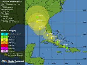
 The Office of Emergency Management is monitoring TS Isaac in the Caribbean Sea.
Current location: approximately 590 miles SE of Miami-Dade County Maximum Sustained Wind Speed: 60 mph
Forward Speed: 17 mph
Forward Direction: Northwest
Potential for further development or weakening: Some strengthening is expected after Isaac moves over eastern Cuba later today and it is expected to become a hurricane on Sunday.
Potential Impact for Miami-Dade County: Miami Dade County is in the 3-day forecast cone. Tropical storm conditions for Southern Florida can be expected on Sunday and hurricane conditions remain a possibility.
Current Miami-Dade County Actions: The EOC is currently at a level 2
Current related watches and warnings for Miami-Dade County: Miami-Dade County is now under a Hurricane Watch and Tropical Storm Warning. Additionally the area near Florida Bay is under a Hurricane Warning.
Miami-Dade Emergency Management will continue to provide updates on this weather system as it evolves. Detailed information on this system can be found at www.nhc.noaa.gov (Mobile: www.nhc.noaa.gov/mobile). For forecast information specific to your area please visit http://weather.gov/miami.


